
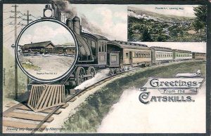
 In an afternoon’s drive, (a short hike and museum visits could easily make it a full day) which spans the length of the Scenic Byway, you will discover many remnants of the rich rail road history here in the Catskills. Much has been lost over the years, but there are still many signs of the heyday of railroading, and the difference the coming of the rails in the 1870’s made here.
1. Starting on Route 28 as you enter the Town of Olive, the railbed of the old Ulster & Delaware Rail Road is on your left, between the Ashokan Reservoir and the road. As you enter the hamlet of Shokan, on your left you see some track and an old Tool House, used for storing track repair tools and occasionally a rail speeder.
2. A brief detour from Route 28, turning at Winchell’s Corner onto Reservoir Road, will bring you to an overpass crossing the old tracks. (Note: this was not the original 1870’s alignment–that route now lies under the Ashokan Reservoir. What you see today was the relocation of track as the reservoir was being built.) Heading back to Route 28, turn left and continue west. As you enter Boiceville, just where the speed limit drops to 45 mph, turn left onto Route 28A, crossing first the Esopus and then the old tracks. After crossing the tracks, make an immediate right turn onto Cold Brook Road, and continue .6 miles.
3. You will see the old Cold Brook depot on your right. Note: this is private property–please respect that, and just view the historic depot from the road. Retrace your steps back to the Byway, turning left and heading through Boiceville.
 4. After entering the Township of Shandaken, you find the Maurice D. Hinchey Catskill Interpretive Center on your right. Take a break from the tour and stop in to enjoy the interesting and informative exhibits, gather detailed information on visiting the Catskills, and if your timing is right attend an event (there are many held throughout the season, check the website for details and information).
Continue west on the Byway. As you cross the Esopus Creek, you can see the open track on your left.
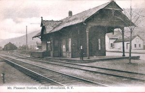
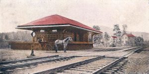
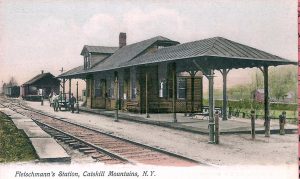
5. Shortly after crossing the Esopus, the Mt. Pleasant depot is on your right. The current depot you see today is a re-creation of the earlier one seen in the photo here to the left. (Just before the depot, there is a pull-off area with picnic tables and a nice historic marker if you wish to take a longer peak around.)
Continue on past the Mt. Pleasant station to head towards Phoenicia and continue on your way down the tracks of rail road history.
 6. On your right, (just after passing the Phoenicia Diner on the left) observe the marker by the rail road track, reading ‘K27‘. All along the U & D, distance was measured from Kingston, so you are 27 track miles from Kingston Point.
Make the first right turn, onto Lower High Street. (There is a sign for the Railway Museum.)
7. On your right you will see the historic Phoenicia Depot, built in 1899. If it is open, a visit to the Empire State Railway Museum gives a wonderful sense of the rail road era here in the Catskills. Dioramas, photos, and the actual depot fixtures all illustrate this remarkably well. At this spot, the Stony Clove branch (1883 – 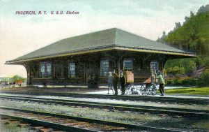 1940 ) broke away from the main line, and climbed up Stony Clove Notch to Hunter , Tannersville, and Haines Falls. (Today’s Route 214 follows the path, for the most part on the other side of the Stony Clove Creek.) But the main line continued to follow the Esopus west of Phoenicia. For break from this tour, stop and visit the hamlet of Phoenicia, on the other side of the Creek from the Depot. Voted one of the ten ’coolest’ towns in America several years ago, there is a wide array of accommodation, recreation, food and shopping options here. As you return to Route 28 and continue west, you will twice cross the old track bed, first just after the Route 42 turn-off, right after the short bridge. You can then see the track, old rail road culverts, and other indications of the rail road on your right as you drive to Big Indian. There the road crosses the tracks again. (In the early days of rail road construction, they attempted to cross water as little as possible, so that however winding the river was, the rails followed it. Today’s Route 28 follows a much straighter course, crossing and recrossing the Esopus many times.)
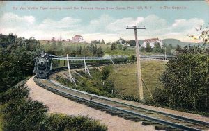
As you approach Pine Hill, you can see the old rail bed high on the hill to your left. From Pine Hill to Highmount, the rail road had to make a steep climb, which was accomplished with a double horseshoe curve – an engineering marvel! Even with this, depending on the number of cars and the amount of freight, helper engines were sometimes needed to make the climb (the helper engines were added on in Big Indian going westbound).
8. At Highmount, you can see the short section of double track, just to the left of the road. If you look up to your right, high on the hill overlooking the depot was the site of the Grand Hotel. Built by the Ulster & Delaware Rail Road in the 1880’s, it was one of the most luxurious hotels in the Catskills. Sadly it is no more–it was taken down in the early 1960’s.
9. The line then descended to Fleischmanns, where the old Freight House still stands. You can see this structure by turning left onto Fleischmanns Heights Road (just before Wadler Brothers.) Bear right as if to cross over the tracks (not left to go UNDER the tracks), but turn in just before the tracks. You are looking at the Freight House. This was the original depot, built in the early 1870’s by the Rondout & Oswego Railroad. Later on, a grander depot was built by the U & D, but that is now gone. If you detour into Fleischmanns, the Greater Fleischmanns Museum of Memories has a great deal of material on local area history, including the rail road era. There are also several lunch options.
You can see the old rails on your left much of the way to Arkville, including a great old metal bridge just before entering Arkville.
 10. The Arkville station is actually part of the original depot, the most complete original R&O depot still standing. You will also see the baggage room end of the Halcottsville depot now used as a tool shed; as in Fleischmanns there was a fancy passenger station built and the current building was turned into just the freight house. Here you can take the Delaware & Ulster Rail Road ride following 11 miles of the old U & D route to Roxbury. But our tour continues straight on the Byway, towards Margaretville.
 11. Shortly past the Arkville Depot, turn right onto Pavilion Rd. About 0.1 miles in, you can see remains of a stone abutment on the left, part of the Delaware & Eastern (later Delaware & Northern) line, which connected Arkville and the U & D to the O & W at East Branch. This was a shorter-lived line, in existence from 1905 until 1942. It served the communities along the East Branch of the Delaware River. (At Highmount you crossed from the Esopus Creek watershed which flows into the Hudson River to the watershed of the Delaware River. See the New York City Water Supply History Itinerary.)
After passing Margaretville, leave the Scenic Byway and turn left to follow Route 30 along the Pepacton Reservoir. (See the related Pepacton Reservoir-to-Andes Side Trip for more info on this leg.) The old rail bed is at the bottom of the reservoir. It originally ran along the far side of the river. Just before the Shavertown Bridge, which crosses the reservoir, turn right onto County Highway 1 to Andes. A spur of the D & E / D & N followed the Tremperskill up to Andes. There are some remnants along the way, but they are on private land. Just after passing Upper Dingle Hill Road, with its historic marker on the Anti-Rent War, (worth a stop and a brief detour) you can clearly see the rail bed on the side of the hill to your left. As you enter the hamlet of Andes, just before Route 1 meets Route 2 to become Main Street, the old Andes depot is above you on your left.
 12. Turn left at the small island (before reaching the blinking light), to head up the hill to the entrance to the depot area. Limited parking is available alongside the road–better parking arrangements are being worked out. The depot has been recently remodeled. At the same time as the depot was being worked on, a Rail Trail was developed, to allow a hike along the old rail bed. There is a great interpretive panel as you enter the trail. It is a fairly level walk, with lovely views. (On the Andes rail trail just a short distance in, the original foundation for the turntable is clearly visible.) Between
 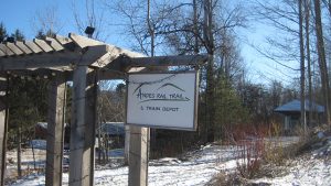 the depot and the trail, you get a good sense of the richness of the local rail road history, and a fitting end to your Scenic Byway Rail visit. Continue on into Andes. At the blinking light you rejoin the actual Byway, and can see the part missed by taking the detour along the reservoir. The Andes Society for History and Culture has a splendid museum at the Hunting Tavern. Be sure to stop at the Scenic Overlook at the top of Palmer Hill on your way back down the Byway.