Where is it?
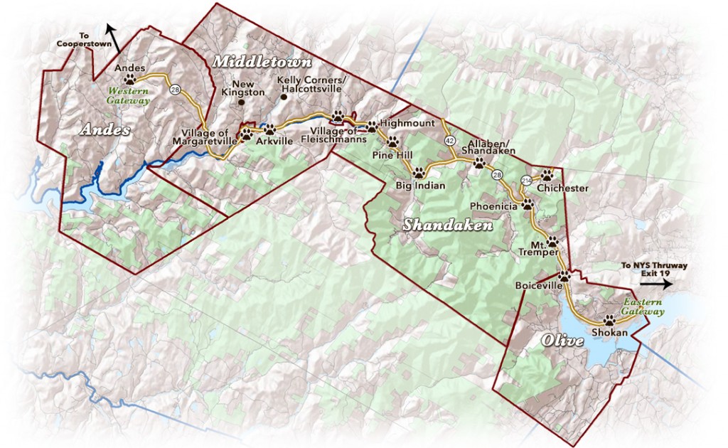
The 52-mile Catskill Mountains Scenic Byway (CMSB) is your gateway to the Central Catskills in southeastern New York State. The Byway begins at the eastern border of the town of Olive on NYS Route 28, about 10 miles west of Exit 19 of the NYS Thruway at Kingston and follows Route 28 North to the hamlet of Andes. The Ulster County portions of NYS Routes 214 and 42 are also part of the State-designated Byway, providing connections to Greene County and the Mountain Cloves Scenic Byway.
The CMSB runs through the Towns of Olive and Shandaken in Ulster County, and the Towns of Middletown and Andes and Villages of Margaretville and Fleischmanns in Delaware County. Along the route, the byway parts with Route 28 for short distances, entering the hamlets of Phoenicia and Pine Hill and the Villages of Fleischmanns and Margaretville before rejoining 28. * In 2016, the byway will follow Old Route 28 between the hamlets of Shandaken and Big Indian while a new bridge is installed.
What Makes it ‘Scenic’?
The CMSB follows the Esopus Creek, which originates on the flanks of the Catskills’ highest peak (4200-foot Slide Mountain), and the East Branch of the Delaware River. Both are fabled trout fishing streams. A ride on 28 offers pristine mountain views and access to wild lands of the Catskill Forest Preserve. The route traverses much of the Catskill Park, a tapestry of public and private lands, and passes Belleayre Mountain Ski Center at the boundary of Ulster and Delaware Counties. A stunning panorama of numerous peaks awaits the traveler atop Palmer Hill (the highest point of elevation on the byway) in Andes near the Byway’s western end. A stunning panorama of numerous peaks awaits the traveler atop Palmer Hill (2200’ elevation) in Andes near the Byway’s western end. Venture up winding Route 214 for a Byway two-fer: CMSB meets the Mountain Cloves Scenic Byway at the Ulster-Greene County line in this narrow mountain pass known as the Stoney Clove. Another side jaunt features Route 42 along Bushnellsville Creek in rugged Lexington.
What Makes it Special?
With much of the region protected as public land, this area has been a mecca for travelers, artists, writers, and seekers of peace and beauty for generations. An authentic, non-commercialized culture is focused largely on natural resource-based industry, small scale agriculture and outdoor recreation like fishing, boating, hiking and hunting. Tourism inspired by the arts, history and a growing local foods movement is an important player in the regional economy. Two giant reservoirs which serve as Byway bookends – the Ashokan and the Pepacton — provide as much as half of New York City’s drinking water, making this a Watershed, Foodshed and Viewshed! Wilderness and wildlife (including the secretive bobcat whose paw is the CMSB logo) coexist with vibrant, quirky small towns.
Who is Behind the Byway?
The Central Catskills Collaborative (CCC), made up of unpaid delegates appointed by the six Byway municipalities (Towns of Olive, Shandaken, Middletown and Andes, and Villages of Fleischmanns and Margaretville) developed the Scenic Byway Corridor Management Plan. The plan details the intrinsic qualities of the byway corridor and outlines future strategies to protect and promote the byway. The plan also serves as the nomination document for New York State designation of the byway, a process that was completed when Governor Andrew Cuomo signed the byway into law in November 2015. The CCC is implementing the plan’s marketing strategy utilizing two state grants. Elected officials who comprise the Route 28 Leaders Group serve as the Byway’s Board of Directors. The Central Catskills Chamber of Commerce is the business administrator.